Sediment Profile Imaging
Sediment Profile Imaging (SPI) technology was developed in the 1980s to provide a rapid and cost-effective method for observing changes at the sediment-water interface of the seafloor. This optical technique is used to image, measure, and analyze physical, chemical, and biological parameters in aquatic sediment environments.
Our scientists have over 20 years of experience using SPI in support of sediment and benthic habitat evaluations for site and impact assessments, dredged material disposal site monitoring, remediation, wood debris and fish waste impact evaluations, and effluent discharge monitoring. As a rapid assessment tool, NewFields has found SPI to be particularly effective for identifying areas of the seafloor impacted by physical and chemical disturbances.
Sediment Profile Imaging Camera
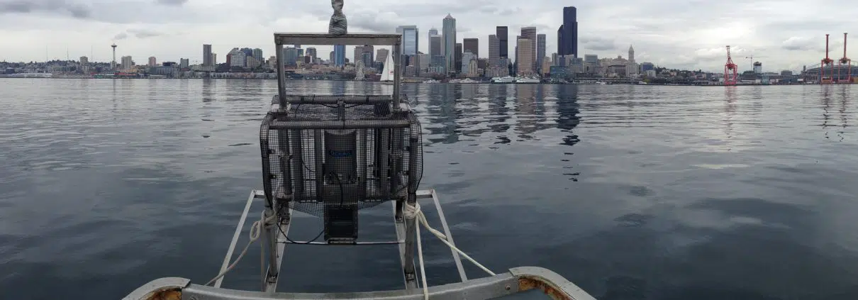
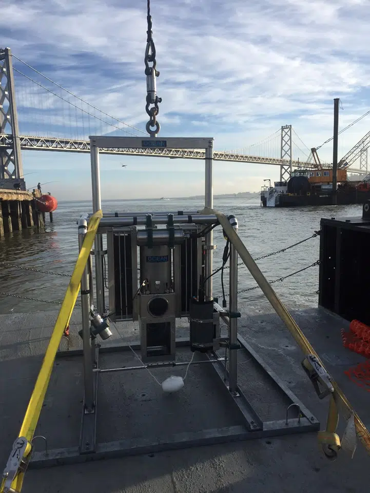
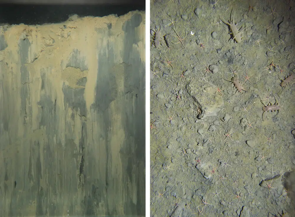
NewFields utilizes high-resolution digital sediment profile imaging systems deployable in up to 4000m of water. A standardized and formalized method is used for SPI image collection, analysis, QA, and interpretation. Many seafloor sedimentary processes can be studied and evaluated by looking at features in the upper 20 cm of the seafloor. SPI provides a cross-sectional image of the sediment/water interface and near-surface sediment (15 by 20 cm area). The SPI camera consists of a wedge-shaped prism with a Plexiglas faceplate and a back mirror mounted at a 45-degree angle. Light is provided by an internal strobe. The mirror reflected the image of the sediment profile to a digital camera mounted horizontally on top of the prism.
For plan view (surface) imaging, NewFields utilizes high resolution underwater digital cameras deployable in up to 4000m of water. The collection of synoptic plan view images has proven useful for providing a broader evaluation of surface sediment types, seafloor processes, and animal identification not visible in SPI.
Image Analysis
A computer-based image analysis and interpretation software are used to measure multiple physical and biological parameters from SPI images. The parameters measured include:
- Sediment type and color
- Prism penetration depth
- Grain size major mode
- Surface boundary roughness
- Mud clasts
- Apparent redox potential discontinuity (RPD) depth
- Presence of oxygen or methane
- Presence of benthic organisms, fecal pellets, burrows, surface tubes, feeding mounds, or feeding voids
- Infaunal successional stage
- Organism-sediment index (OSI)
- Benthic habitat quality index (BHQI)
- Non-native attributes
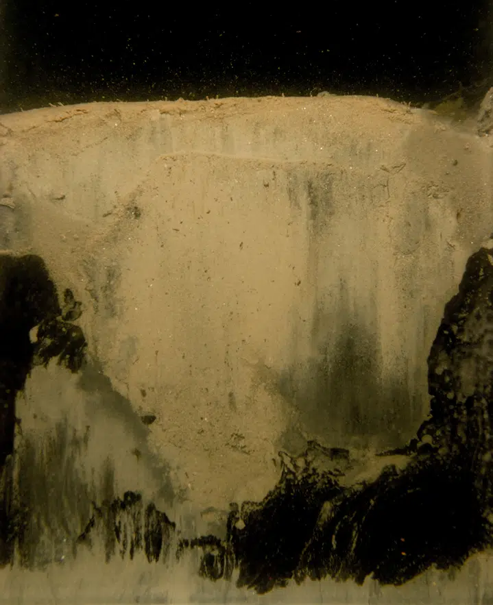
Sediment profile image and plan view image of dredged material
NewFields works closely with our clients to determine the study design and select the key SPI parameters that address the objectives of their study.
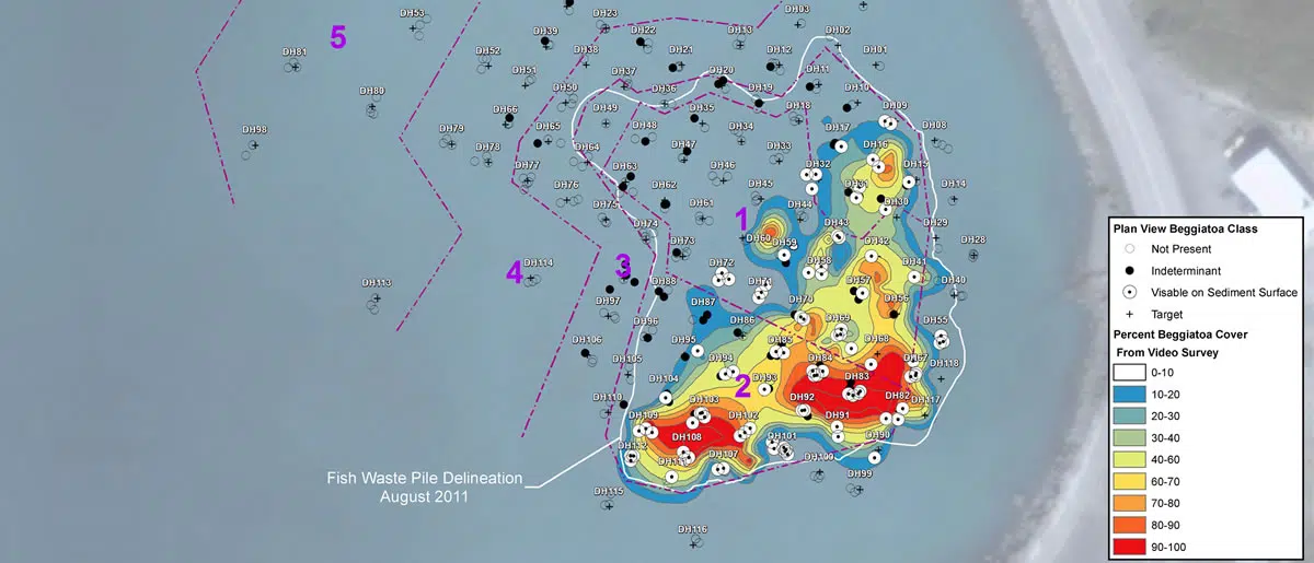
Mapping habitat recovery at a seafood waste restoration site
Sediment Profile Imaging Applications
SPI technology is used for a wide variety of applications to support investigations for U.S. and international customers:
- Mapping the distribution of dredged material at open water disposal sites in both fine-grained and sandy environments;
- Sand mining reconnaissance and impact monitoring;
- Baseline and monitoring of offshore exploratory drilling sites and cable or pipeline corridors on the seafloor;
- Impact assessment of oil and drilling mud releases from offshore oil-drilling platforms;
- Construction monitoring of sediment capping projects and Confined Aquatic Disposal (CAD) sites;
- Measurement of aquaculture impacts due to salmon and mussel farms;
- Effluent discharge monitoring (e.g., outfalls, wood pulp, and seafood waste); Mapping the distribution and impact of wood debris near log storage and wood industry sites;
- Refinement of sediment sampling designs through SPI reconnaissance;
- Mapping of erosional, non-depositional areas and/or low energy depositional sites; and
- Identification of areas with chronic organic overloading.
A few examples highlighting NewFields’ experience in these applications are provided below.
Dredged Material
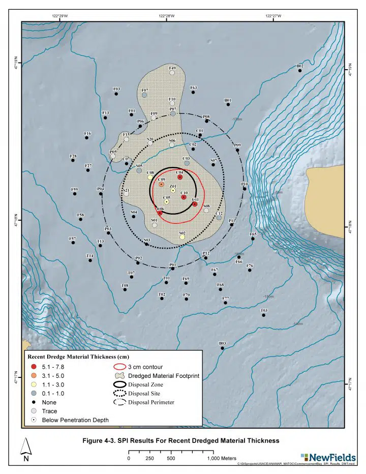
NewFields conducts environmental monitoring of ocean dredged material disposal sites, having conducted studies along the west coast of the United States (Alaska, Washington, Oregon, and California), Texas, coastal Florida, and Vancouver B.C. Canada. NewFields utilizes SPI and plan view imaging to map the extent of recent dredged material deposition and determine impacts to the benthic habitat. NewFields regularly conducts monitoring at the San Francisco Deep Ocean Disposal Site (SF-DODS), a dredged material disposal site located 50 miles off the coast of California in 3,000 meters of water.
Dredged material distribution map
Oil Releases
NewFields conducted multiple SPI surveys in the Bohai Sea, China, to map the extent of an oil spill in surface sediments around a drilling rig and evaluate the apparent impacts to benthic habitat. Visual cues in the collected SPI images were used to map the presence/absence of 1) native depositional sediment; 2) visible oil-based drilling mud; and/or 3) evidence of petroleum in sediments. Key SPI images analysis parameters for evaluation of the sediment and benthic habitat quality included: penetration depth, sediment grain size, surface roughness, the depth of the apparent redox potential discontinuity (RPD), benthic habitat categories, infaunal successional stage, and the determination of the Organism-Sediment Index (OSI).
Sediment Profile Image of oil-based drilling mud
Seafood Waste
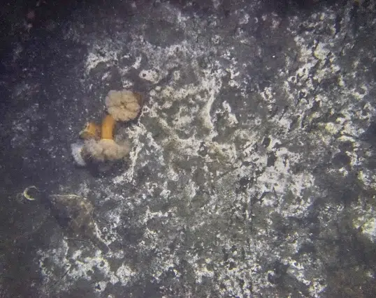
SPI and plan view imaging surveys were conducted by NewFields to delineate the areal extent and benthic habitat impact of legacy fish waste piles created from seafood processing plant outfalls at a site in Alaska. The focus of the benthic impact survey was to map the extent of the waste pile and identify the areas of benthic habitat impact based on SPI parameters. NewFields conducted additional SPI and plan view surveys at the impact site to help inform the remedial alternatives analysis for site cleanup and to monitor impacts and residuals before and after seafood waste removal by dredging.
Plan View image of fish waste
Sand Mining
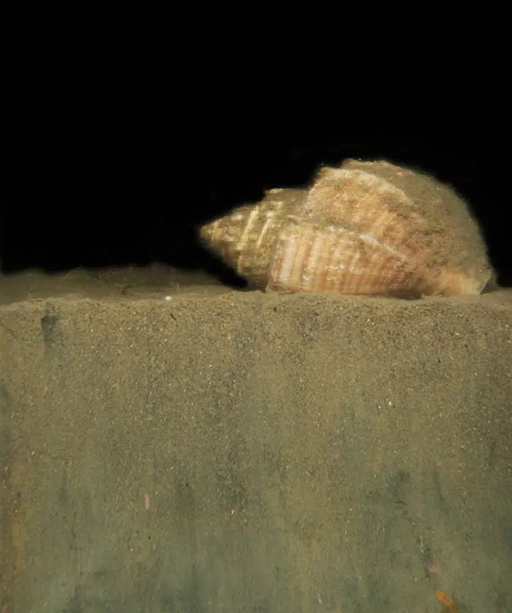
NewFields conducted a study utilizing SPI to evaluate the impacts of aquatic sand mining on benthic habitats. The focus of the study was to determine the effects of sand mining on benthic communities and evaluate how the disturbance impacts habitat function relative to fish and epibenthic organisms. SPI was used to help characterize benthic habitat conditions impacted by sand mining activities and inform the rate of recovery over time.
Sediment Profile Image of sandy substrate



 LinkedIn